Philippines, Friday Morning, 12/05, 10:30 am PHT: Due to upper wind shears and a changing high pressure ridge, computer models are forecasting a reduction in strength and forward motion. Here are bullet point highlights as of this morning from multiple weather sources:
Visit our Super Typhoon Hagupit Live Update Page
-

- Boarding up the church in advance of Typhoon Ruby’s landfall.
-

- Church members board up Ormoc Church of the Nazarene, in process of being rebuilt after Typhoon Yolanda.
-
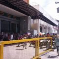
- Lining up to buy supplies in advance of the storm’s landfall.
- Currently Category 5 Storm with 175 mph winds. Central Pressure of 905mb.
- Feeder bands are bringing gusty winds, heavy seas, and heavy showers to Samar and Leyte Islands (areas heavily damaged by last year’s Super Typhoon Yolanda – thousands are still living in tents).
- Satellite images show the eye with a 14-mile diameter.
- Expected to make landfall as a Category 4 storm with winds around 240 kph (150 mph) in the Central Visayas Region.
- Forward progression has slowed from 34 to 23 kph (21 to 14 mph).
- Models seem to show it passing just north of the area impacted by Super Typhoon Yolanda in November of 2013.
- Nazarene Disaster Response (NDR) teams are working with District Superintendents to alert local churches, assess emergency supplies and resources on hand, and provide preparation guidance as necessary.
- Command posts and leadership have been assigned to key locations throughout the central Philippines.
- NDR Teams are collaborating with government agencies and other aid agencies as initial preparations are made.
Please continue to pray for all of those who are in the path of the storm and for those who are making preparations in the event of landfall.
—- Credit weather information from weather underground.