
Typhoon Nari (Santi) Update from Manila October 11th, 2013
Link to most current updated tropical storm map
Manila, Philippines: Torrential rains have been falling on Manila since around 3 pm local time today (Thursday) with some reports of flooding already being received. The current forecast is that Typhoon Nari will make landfall in the early morning hours of Saturday, October 12th. Manila is situated on the southern edge of the projected storm track. Please keep the Philippines in your prayers in the days ahead. Check back for updates over the next 48-72 hours.
weather.com.ph update
TYPHOON NARI (SANTI) UPDATE NUMBER 007
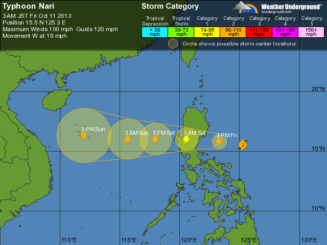
Issued at: 7:30 AM PhT (23:30 GMT) Friday 11 October 2013
Typhoon NARI (SANTI) has accelerated westward during the past 12 hours while intensifying rapidly over the Central Philippine Sea…now endangers Central and Northern Luzon. Its western outer rainbands are spreading across the whole of Luzon including Metro Manila and Bicol Region…likely to make landfall over Aurora this evening.
Residents and visitors along Luzon including Metro Manila and Bicol Region should closely monitor the development of Nari (Santi).
Do not use this for life or death decisions. This update is intended for additional information purposes only. Kindly refer to your national weather agency for official warnings, advisories or bulletins.
CURRENT STORM ANALYSIS
As of 5:00 am today, the eye of TY Nari (Santi) was located over the western part of the Central Philippine Sea…about 170 km north-northeast of Pandan, Catanduanes or 275 km east-southeast of Casiguran, Aurora…currently moving west-northwest with an increased forward speed of 24 km/hr towards Aurora and Nueva Ecija Provinces.
Maximum Sustained Winds (1-min. avg) have rapidly increased to 160 km/hr near the center with higher gusts.Typhoon Force Winds (118 km/hr or more) extend outward up to 35 kilometers from the center…and Tropical Storm Force Winds (63-117 km/hr) extend outward up to 140 kilometers. Nari (Santi) has grown into a large-sized tropical cyclone with a diameter of 685 kilometers across. The 24-hour rainfall accumulation near the center of Nari (Santi) is estimated to be extreme (400 mm).
2-DAY FORECAST OUTLOOK*
TY Nari (Santi) is expected to move generally westward with an increase in forward speed during the next 24 through 48 hours. On the forecast track, the core of Nari (Santi) will be passing well to the north of Bicol Region this morning…and will be just off the coast of Northern Aurora this afternoon. By this evening, Nari (Santi) will make landfall over Aurora somewhere over or very close to the town of Baler…and will traverse the provinces of Nueva Ecija and Pangasinan late tonight through Saturday early morning before moving out into the West Philippine Sea. Throughout Saturday, the typhoon will be cruising along the Scarborough (Panatag) Shoal in the West Philippine Sea, exiting the Philippine Area of Responsibility (PAR) on Sunday morning.
TY Nari (Santi) will continue to intensify during the next 6 to 12 hours. Advance Intensity Forecast (AIF) shows its 1-minute maximum sustained winds reaching 175 km/hr before it makes landfall over Aurora Province tonight.
The following is the summary of the 2-day forecast outlook and an extended 3-day forecast on this system:
SATURDAY MORNING: Weakens to a Category 1 TY while over Western Pangasinan…about 55 km west of Dagupan City, Pangasinan [5AM OCT 12: 16.0N 119.8E @ 150kph].
SUNDAY MORNING: Cruising over the West Philippine Sea as it exits PAR…regains Category 2 strength…about 515 km west of Cape Bolinao, Pangasinan [5AM OCT 13: 16.1N 115.0E @ 165kph].
MONDAY MORNING: Still heading westward…intensifies more as it approaches the coast of Central Vietnam…about 335 km south-southeast of Qionghai, Hainan Island [5AM OCT 14: 16.3N 111.4E @ 175kph].
*Please be reminded that the Forecast Outlook changes every 6 hours, and the Day 2 and 3 Forecast Track has anaverage error of 100 and 250 km respectively…while the wind speed forecast error, averages 35 kph per day. Therefore, a turn to the left or right of its future track and changes in its wind speed must be anticipated from time to time.
EFFECTS & HAZARDS SUMMARY
Below is the summary of the storm’s parts and its hazards affecting specific areas. You can also view this image linkfor you to understand the parts.
CLOUD-FILLED EYE – Western Part of Central Philippine Sea. Possible calm and lull conditions (with <20 kph winds) will be expected inside the eye (click here to know more about the EYE).
EYEWALL – where Typhoon Conditions with Typhoon Force Winds (>118 kph) will be expected within this wall.Affected Areas: Western Part of Central Philippine Sea.. (click here to know more about the Eyewall).
INNER RAINBANDS – where Tropical Storm Conditions with Tropical Storm Force Winds (63-100 kph) will be expected. Affected Areas: Coastal areas of Partido District in Camarines Sur and Camarines Norte, Catanduanes and the Western Part of Central Philippine Sea.
OUTER RAINBANDS – where Tropical Depression Conditions with light, moderate to strong winds (30-62 kph) will be expected. Affected Areas: Western Part of Central Philippine Sea and the whole of Luzon including Metro Manila, Rest of Bicol Region, Mindoro, Masbate, and Panay. (click here to know more about Rainbands).
24HR TOTAL RAINFALL ACCUMULATION – from 5 up to 100 mm (slight to heavy rainfall) can be expected along areas affected by the outer & inner rainbands (see above)…with isolated amounts of 101 to 400 mm (heavy to extreme) along areas to the west, south and near the center of Nari (Santi).
COASTAL STORM SURGE FLOODING – possible 6-8 ft (1.8-2.6 m) above normal tide levels…accompanied by large and dangerous battering waves can be expected along the coastal, inland lakes and beach front areas of Eastern Luzon today. Moderate damage is likely on this type of storm surge. Danger from Rip Currents or Rip Tides can be expected along the rest of the beach-front areas of Luzon and Northern Visayas (click here to know more about Storm Surge).
Important Note: Please keep in mind that the above forecast outlook, effects and hazards summary changes every 6 to 12 hrs!